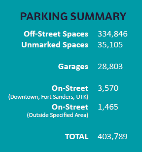
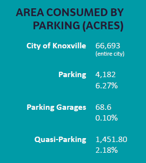
Knoxville-Knox County Planning recently completed a parking space count for the City of Knoxville. The project started with work compiled by an undergraduate GIS class at the University of Tennessee and completed by an intern and other staff. The data was then analyzed, looking at parking spaces throughout the city for customers, employees, residents (multi-dwelling units with parking lots, not single-family homes), and students. The parking count did not include truck loading and unloading, temporary trucks lots, car sales lots, or abandoned or overgrown lots. Those spaces were, however, counted as “quasi-parking.” In the entire city, 4,182 acres are consumed by parking, which is 6.27 percent of the city’s land. Another 1,452 acres are consumed by quasi-parking, which is an additional 2.18 percent. In our analysis, we looked at how much space (percent) parking took up in each land use. The ranking was:
Commercial
Public and quasi-public land (parks, schools, and churches)
Office
Multifamily residential
Right of way (roads)
Then, for each land use, we took out the amount of land consumed by parking and counted parking as its own land use (even though it isn’t traditionally) to see how it compared. In this exercise, we ranked the different land uses by area in acres and came up with the following: This analysis shows us that roughly a quarter of our city is consumed by pavement, with 17% dedicated to roads and 8% to parking. We put this information together and took it to Knoxville’s Park(ing) Day event, which took place on Gay Street on September 20. The event is recognized around the world by groups and individuals who claim a parking space for the day and dedicate it to human use instead of a parked car. Many people create small park spaces, drawing attention to the incredible amount of space our cities have dedicated to cars and how that space could be repurposed for people to use. At the event, we had an activity set up where we asked participants to guess the percentage of land consumed by different uses in the city. Most people were surprised by how much land was dedicated to cars, especially when compared to other uses. We also asked people to guess how many parking spaces there were at East Town Mall, Downtown West, and Carson Point on Chapman Highway. They were again surprised by just how much parking is located at these locations. Finally, we had information set up to get people thinking about possible redevelopment opportunities for all those parking lots. We often hear that development opportunities within the city limits are limited because almost all the land has already been developed. But with the amount of space taken up by parking (and much of it underutilized) and the increased flexibility allowed within the city’s updated zoning ordinance, which is set to go into effect January 1, 2020, there are opportunities to make use of those spaces. An example of that is the announcement of Stockyard Lofts, a mixed-use development proposed for what is currently a parking lot in the Old City. Planning’s interest in this was sparked by the CityLab article, “Parking has Eaten American Cities,” which compares the amount of land consumed by automobile parking in five other U.S. cities and considers the implications of that use. So, has parking eaten Knoxville? Our analysis shows that eight percent of our city is taken up by parking. That may not sound like a lot, until you consider how much of that space is underused or unused. Taking that in account allows us to start thinking about how we can reuse and repurpose some of those spaces, whether it’s by creating a small park or a mixed-use development with 152 apartments and 5,000 square feet of retail space.
 In the entire city, 4,182 acres are consumed by parking, which is 6.27 percent of the city’s land. Another 1,452 acres are consumed by quasi-parking, which is an additional 2.18 percent. In our analysis, we looked at how much space (percent) parking took up in each land use. The ranking was:
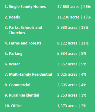 This analysis shows us that roughly a quarter of our city is consumed by pavement, with 17% dedicated to roads and 8% to parking. We put this information together and took it to Knoxville’s Park(ing) Day event, which took place on Gay Street on September 20. The event is recognized around the world by groups and individuals who claim a parking space for the day and dedicate it to human use instead of a parked car. Many people create small park spaces, drawing attention to the incredible amount of space our cities have dedicated to cars and how that space could be repurposed for people to use.
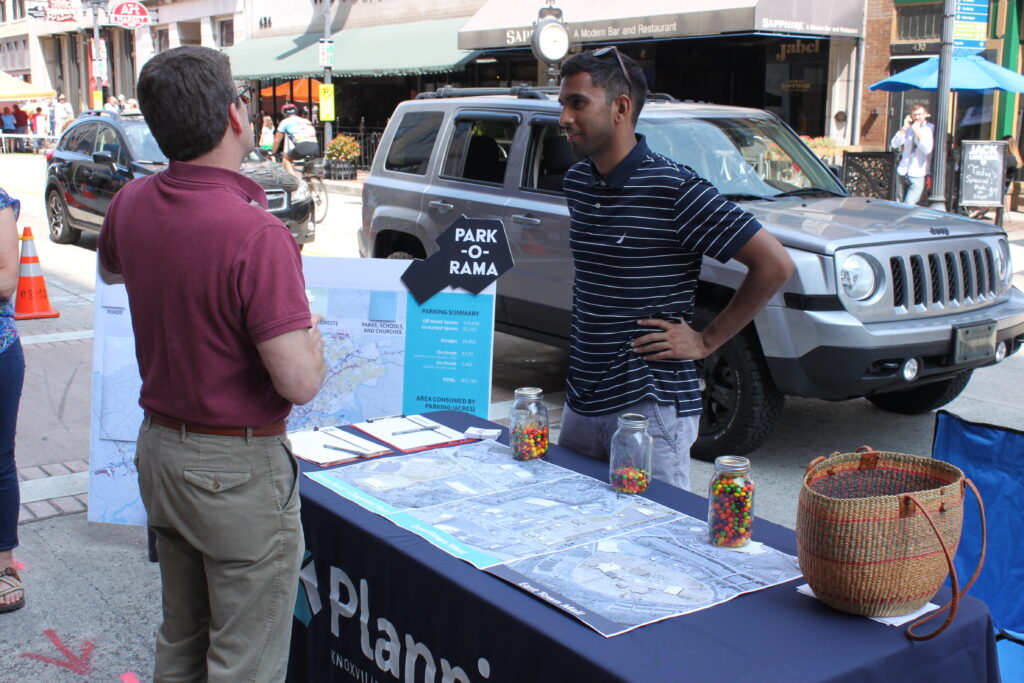
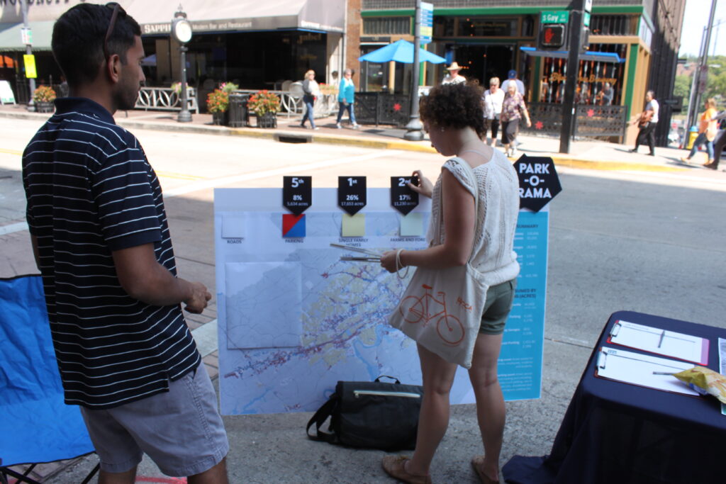
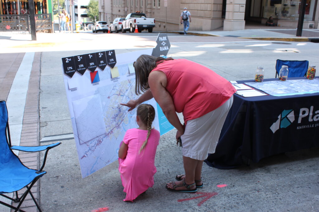 At the event, we had an activity set up where we asked participants to guess the percentage of land consumed by different uses in the city. Most people were surprised by how much land was dedicated to cars, especially when compared to other uses. We also asked people to guess how many parking spaces there were at East Town Mall, Downtown West, and Carson Point on Chapman Highway. They were again surprised by just how much parking is located at these locations.
 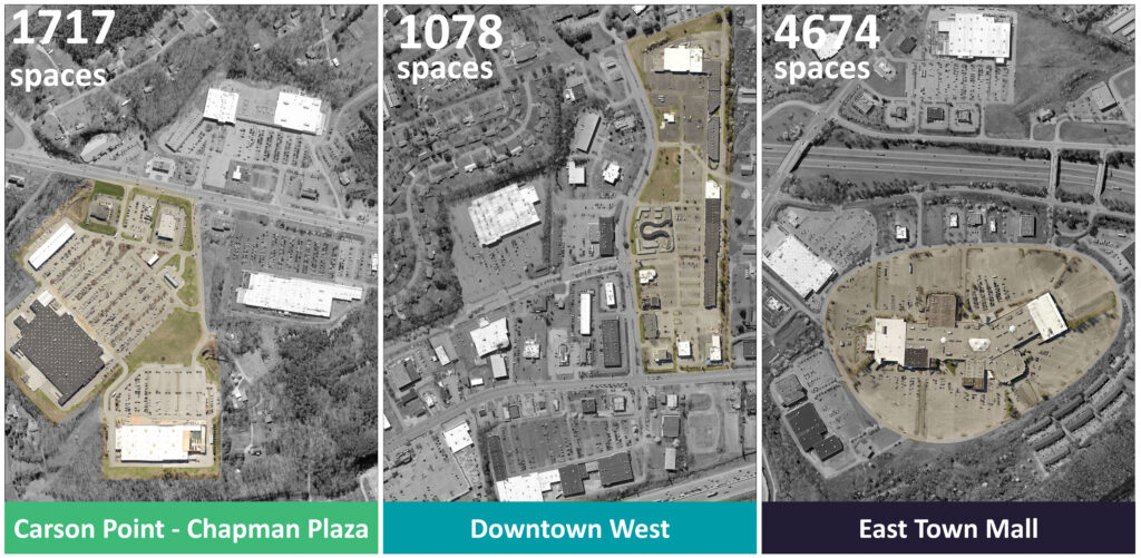 Finally, we had information set up to get people thinking about possible redevelopment opportunities for all those parking lots. We often hear that development opportunities within the city limits are limited because almost all the land has already been developed. But with the amount of space taken up by parking (and much of it underutilized) and the increased flexibility allowed within the city’s updated zoning ordinance, which is set to go into effect January 1, 2020, there are opportunities to make use of those spaces. An example of that is the announcement of Stockyard Lofts, a mixed-use development proposed for what is currently a parking lot in the Old City. Planning’s interest in this was sparked by the CityLab article, “Parking has Eaten American Cities,” which compares the amount of land consumed by automobile parking in five other U.S. cities and considers the implications of that use. So, has parking eaten Knoxville? Our analysis shows that eight percent of our city is taken up by parking. That may not sound like a lot, until you consider how much of that space is underused or unused. Taking that in account allows us to start thinking about how we can reuse and repurpose some of those spaces, whether it’s by creating a small park or a mixed-use development with 152 apartments and 5,000 square feet of retail space.